
ছবি:NepalArghakhanchiDistrictmap.png

আয়ৌপা ফাইলগ (৩,৫০৮ × ২,৪৭৯ পিক্সেল, ফাইলর সাইজহান: ২৮৫ কিলোবাইট, এমআইএমই-র অংতা: image/png)
| বারে |
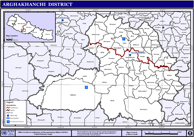
English: Map displaying Village Development Committees in Arghakhanchi District, Nepal |
|||
| তারিখ | ||||
| উৎস | http://www.un.org.np/maps/district-maps/western/Arghakhanchi.pdf | |||
| ইকরেকুরা | United Nations | |||
| অনুমতি (এ ফাইলের পুনঃব্যবহার) |
|

ফাইলর ইতিহাস
দিন/সময়-র গজে যাতিলে ঔ খেন্তাম পেয়া হঙিসে ফাইলগ চ পারতেই।
| দিন/সময় | হুরকাকরে ফটকগি | চাঙহান | আতাকুরা | মতহান | |
|---|---|---|---|---|---|
| এপাগা | ০১:২৮, ৬ নভেম্বর ২০০৮ | | ৩,৫০৮ × ২,৪৭৯ (২৮৫ কিলোবাইট) | Sadalmelik | {{Information |Description={{en|1=Map displaying Village Development Committees in Arghakhanchi District, Nepal}} |Source=http://www.un.org.np/maps/district-maps/western/Arghakhanchi.pdf |Date=March 4, 2008 |Author=United Nations |Permission={{PD-UN}} |
জুরিসিতা
এরে ফাইলর লগে পাতার মিলাপ আসে:
ফাইলের বৈশ্বিক ব্যবহার
নিচের অন্যান্য উইকিগুলো এই ফাইলটি ব্যবহার করে:
- de.wikipedia.org-র ব্যবহারহান
- en.wikipedia.org-র ব্যবহারহান
- fi.wikipedia.org-র ব্যবহারহান
- hi.wikipedia.org-র ব্যবহারহান
- ग्राम विकास समिति
- साँचा:अर्घाखाँची जिला
- असुरकोट
- अडगुरी
- अर्घातोस
- केरुङ्गा
- खन
- खनदह
- खिदीम
- खिल्जी
- गोखुङ्गा
- सन्धिखर्क नगरपालिका
- चिदीका
- हंशपूर
- धारापानी
- धनचौर
- ठुलापोखरा
- ढाकावाङ्
- छत्रगञ्ज
- जलुके
- जुकेना
- ठाडा
- नुवाकोट, अर्घाखाँची
- पटौटी
- पणेना
- पाली गाविस
- सुवर्णखाल
- सीतापुर, अर्घाखाँची
- मैदान, अर्घाखाँची
- पोखराथोक, अर्घाखाँची
- सिमलपानी
- सिद्वारा
- बल्कोट
- बाँगी
- भगवती, अर्घाखाँची
- मरेङ
- mai.wikipedia.org-র ব্যবহারহান
এই ফাইলের অন্যান্য বৈশ্বিক ব্যবহার দেখুন।